Foto-Galerie (Einzelbeschreibung)
|
|
Titel:
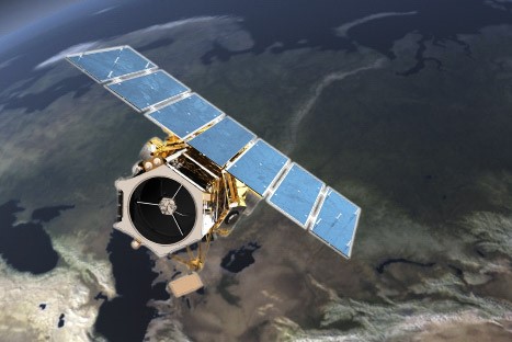
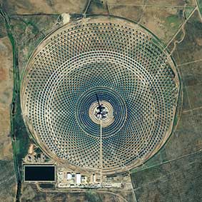
oben: GeoEye-1 unten: Gemasolar Thermosolar Plant - Solarwärmekraftwerk, aufgenommen von GeoEye-1 am 4.11.2010 Quellen:GeoEye-1: The World's Highest Resolution Commercial Earth-Imaging Satellite http://de.wikipedia.org/wiki/GeoEye-1 http://www.atlisvue.com/wp-content/uploads/2013/02/satellite-geoeye1.jpg Originalauflösung:-- Sonstiges:
|
|
Beschreibung / Hintergrund:
GeoEye-1 ist ein ursprünglich als OrbView-5 bezeichneter, kommerzieller Erdbeobachtungssatellit der Firma GeoEye mit Start am 6. September 2008 von der Vandenberg Air Force Base mit einer Delta-II-Rakete. Die räumliche Auflösung seiner Sensoren beträgt 0,41 m im panchromatischen und 1,65 m im multispektralen Bereich. Da die panchromatischen und die multispektralen Daten gleichzeitig aufgenommen werden, ist die Betreiberfirma durch die Kombination beider Datensätze in der Lage, Farbbilder mit 0,41 m Auflösung anzubieten ('pan-sharpened'). Auch stereoskopische Bilder sind möglich. Er befindet sich auf einer 681 km hohen sonnensynchronen Umlaufbahn mit einer Bahnneigung von 98,1°. Die Schwadbreite beträgt dabei 15,2 km wobei die Kameras bis zu 60° außerhalb der Senkrechten Bilder aufnehmen können. GeoEye-1 erfasst täglich eine Fläche doppelt so groß wie Deutschland und schickt die Daten zur Verarbeitung an die Bodenstationen. Dazu verfügt der 1955 kg schwere Satellit über eine interne Speicherkapazität von 1 Terabit und einen Übertragungskanal mit 150 oder 740 MBit/s im X-Band. Kunden sind unter anderem das US-Landwirtschaftsministerium, Google und die National Geospatial-Intelligence Agency. Als Lebensdauer des Satelliten sind mehr als sieben Jahre geplant, wobei der Treibstoffvorrat für 15 Jahre ausgelegt ist. Hersteller ist General Dynamics Advanced Information Systems (AIS). Der Auftrag für den Bau von GeoEye-2 wurde an Lockheed Martin vergeben. Der Start dieses Nachfolgers war für Frühling 2013 geplant, wurde aber abgesagt, nachdem sich das Unternehmen GeoEye mit dem Konkurrenten DigitalGlobe zusammengeschlossen hatte. Der Satellit wurde auf unbestimmte Zeit eingelagert. At the time of its launch, GeoEye-1 was the world’s highest resolution commercial earth-imaging satellite. Google, which has its logo on the side of the rocket, has exclusive online mapping use of its data. While GeoEye-1 is capable of imagery with details the size of 41 cm (16 in), that resolution will only be available to the US government. Google will have access to details of 50 cm (20 in). Prior maximum commercial imagery was 60 centimetres (24 in). Gemasolar Thermosolar Plant near Seville, Spain looks a bit like a giant human eye from space. On closer examination, the center of the eye features a concrete solar tower that stands forty stories high. It is ringed by 2,650 mirrors that blast scorching rays of sunlight to the tower, which stores the heat and converts it to energy. When the plant is completed in 2013, it will provide enough energy to fuel the city of Seville. The plant works on molten salt heat storage system. It is located within the city limits of Fuentes de Andalucía in the province of Seville, Spain. Gemasolar is the first commercial solar plant with a central tower receiver and molten salt heat storage technology. It consists of a 185 ha solar field that has a 140-m high tower receiver, a power island and 2650 heliostats. | |


