Foto-Galerie (Einzelbeschreibung)
|
|
Titel:
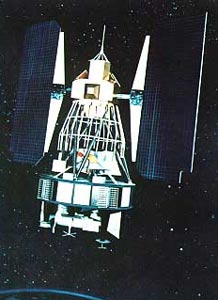
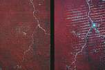
oben: Landsat 1-Satellit unten: Landsatbilder zur Entwaldung in Brasilien; Vergleich der Situation am 19. Juni 1975 mit der am 19. August 1986 Quelle:http://de.wikipedia.org/wiki/Landsat http://www.geog.ucsb.edu/~jeff/115a/ history/landsat1.html -- Sonstiges:-- |
|
Beschreibung / Hintergrund:
Launched on July 23, 1972 and carried the MSS (MultiSpectral Scanner) which imaged the earth from a 900 km altitude with green, red and two IR spectral bands at 80m resolution. It was originally called ERTS 1 (Earth Resources Technology Satellites) but renamed Landsat, and was designed after the Nimbus 4 meteorological satellite. Landsat 1 had a near-polar sun synchronous orbit and was also equipped with a three-camera return beam vidicon (RBV) system that could obtain visible and near IR photographic images of the earth. Landsat 1 was terminated on January 6, 1978, when the degradation of the orbit caused it to see almost constant sunlight which led to overheating. The planning that led to the launch of Landsat began in 1967 as a collaborative effort by NASA and Dept of Interior (USGS). Landsat 1 was a test of the feasibility of an earth resources satellite system, and the determination of the spectral wavelengths was primarily based on forestry and geologic applications that had traditionally used Color IR photography. The MSS sensor was carried on Landsat-1 and subsequently on Landsat-2 and 3. The MSS sensor became secondary to the TM sensor on Landsat-4 and Landsat 5 (which operated for 17 years), the last MSS image to be received in Australia was on the November 30, 1997. Landsat is the only source of historical image data for many parts of the world and MSS data are become extremely useful in studies of change. |
|